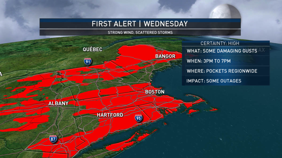
Our NBC10 Boston, NECN and Telemundo New England weather team continues a First Alert for Wednesday afternoon and evening, specifically between 3 p.m. and 7 p.m., for pockets of damaging wind gusts.
Wednesday started deceivingly quiet – a blend of sun and clouds and a steady but unremarkable southwest wind combining to carry temperatures from early readings in the 40s and 50s to midday and afternoon temperatures over 70 degrees for most, 60s north.
A strengthening storm center in southern Quebec will cause an increasing wind field across New England from the southwest by afternoon, escalating gusts to 50 mph by day’s end and as high as 55 mph on Cape Cod.
Download our free mobile app for iOS or Android to get the latest breaking news and in-depth coverage of COVID-19.
As the storm center drags a cold front from northwest to southeast across New England, scattered showers and thunder will develop from late morning and midday in Vermont, to early and middle afternoon in central New England and late afternoon to evening in southern New England.
Although the air is dry and not much rain is anticipated, simply having showers and thunderstorms can assist in focusing already strong winds to the ground, causing for some exaggerated wind gusts that may enhance localized damage, resulting in at least some widely scattered power outages Wednesday afternoon and evening.
Perhaps the biggest impact will come to outdoor dining and retail with large tents – these tents should be secured in the quiet morning hours before the widespread gusts of 50 mph arrive from 3 p.m. onward.
Behind the cold frontal passage Wednesday evening, the wind will shift to blow from the west and northwest, but remain gusty to 40 mph and even higher in the hills and mountains, unlikely to cause much new damage but certain to be heard outside the house through the night as a fresh shot of crisp fall air moves in.
Thursday and Friday deliver plenty of sunshine but high temperatures only near 60 Thursday (near 50 in the North Country!) and 60s Friday (50s north). This time of the year is known for windy days, and wind can change air quickly – Saturday will be a great example of that as a southwest wind increases again and sends daytime high temperatures well into the 70s and even near 80 in southern New England…for a day.
Another cold front Saturday night may deliver a shower ahead of a shifting wind, yet again, with cool air returning. There’s some question in our forecast as to how quickly showers creep into the forecast next week – some of the moisture a diffused remnant of Hurricane Delta, which will make landfall in Louisiana Friday – but right now our First Alert Team is keeping the chance of showers limited to the middle and end of next week without much significant rain accumulation in our First Alert 10-day forecast.
"first" - Google News
October 08, 2020 at 01:33AM
https://ift.tt/34xLUxg
FIRST ALERT: Thunderstorms to Bring Strong Winds, Potential Outages - NBC10 Boston
"first" - Google News
https://ift.tt/2QqCv4E
https://ift.tt/3bWWEYd
Bagikan Berita Ini


0 Response to "FIRST ALERT: Thunderstorms to Bring Strong Winds, Potential Outages - NBC10 Boston"
Post a Comment