I'm wishing you a very happy holiday and a Merry Christmas.
Honestly, the most surprising way we could have ended 2020 was with calm weather. Therefore, no one is surprised that temps will be back and forth and we'll have a chance for rain and snow.
That said - don't believe the hype. Don't share the click-bait. There are those who will use scare tactics to grab your attention and make their money. It happens all year, but especially in winter. Not here. Let's get real.
FIRST, A WARM UP
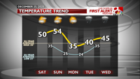
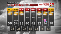
The final Saturday and Sunday of 2020 will be 10-15º above average with highs near 50º on Saturday and into the middle 50s on Sunday. It'll be breezy on Sunday with gusts around 25 mph bringing in those warm temperatures.
Saturday morning will be in the middle 20s and Sunday morning the middle 30s.
NEXT WEEK'S STORM SYSTEM
We'll have high pressure from the north on Monday that will bring us back down to reality with highs in the middle 30s. At this time we'll be able to get a good sense of the main storm system, a low pressure system out west. It will quickly develop and move over the Great Plains on Tuesday.
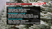
Tuesday's temps will likely reach around 40 in the afternoon. The system will still be to our west and moisture may be lacking. Therefore, I don't expect too much precipitation for us on Tuesday. For now. The majority of our moisture will arrive on Wednesday.
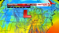
Wednesday is the day to watch. Since this system will slowly move from our northwest to our northeast, our winds will change direction, hence changing our air temperatures at the surface. That's important because that means any rain will then change to snow.
That said, at this point (4-5 days out) I expect rain to start Wednesday due to temps in the 40s. As the system pushes east in the afternoon, and a cold front kicks through, I expect our temperatures to plummet. This will change any rain into snow assuming moisture is still available behind the frontal boundary.
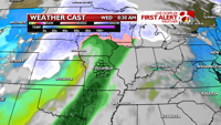
I do not expect any snow that does form to fall for long. The system will have a good speed to it and the cold air from the northwest should push it out of here pretty quickly.
A few flurries may stick around into Thursday morning.
Again noting this is still an "early" forecast for winter weather, I think about 1" of rain is possible with less than 0.5" of snow to end Wednesday.
For the millionth time, this can change. Please stay tuned. Don't believe hype you see online. There are always worst-case scenarios but that's rarely the outcome and it's important to keep a level head when talking about winter weather forecasting.
I've told you what I've forecasted, now here are some of the caveats that could change my forecast in the coming days:
- If we do end up getting more moisture on Tuesday that could create a cooling effect due to evaporative cooling and may mean a better chance for a wintry mix and more snow.
- If the low pressure system pushes further south than its current track that too would mean a better chance for more snow.
There are always factors and variables in winter weather forecasting, the most difficult forecasting of the year. To be honest, that's what makes my job exhilarating, stressful, and draining. It's all of you who keep me diligent and hard working to give you the best possible forecast. Thank you!
I'll also note if you don't want to listen to me, please only listen to other trusted, level-headed, non-hype, non-scare meteorologists (and make sure it's a meteorologist!). And for the love of everything that's good, please don't share something that is hyped and scary. That's what they want, to scare us all for money and then have you question actual meteorologists who didn't give that forecast in the first place. "They said it was going to _____ and then it didn't happen!" is the scariest phrase because "they" is not "all". Okay, down from my soap box. :)

GOODBYE 2020
As we begin 2021 you can expect temps to be seasonal with highs in the 30s.
As the Ball drops and the clock strikes midnight, temps should be in the 20s.
I hope you have a safe and healthy holiday season.
"first" - Google News
December 26, 2020 at 08:15AM
https://ift.tt/38EwokW
FIRST ALERT: Tracking a storm system to end 2020 - KOMU 8
"first" - Google News
https://ift.tt/2QqCv4E
https://ift.tt/3bWWEYd
Bagikan Berita Ini


0 Response to "FIRST ALERT: Tracking a storm system to end 2020 - KOMU 8"
Post a Comment