- The National Hurricane Center is tracking its first area for development in the Atlantic in 2020.
- A tropical or subtropical storm is expected to form near or just north of the Bahamas this weekend.
- Once it becomes a storm, It will be named 'Arthur'.
- It is then expected to track northeast, but remain off the Southeast coast through early next week.
The first tropical or subtropical storm of the 2020 Atlantic hurricane season, "Arthur", is expected to form near the Bahamas this weekend and could bring some rain, breezy conditions, high surf and rip currents to parts of the Southeast coast into next week.
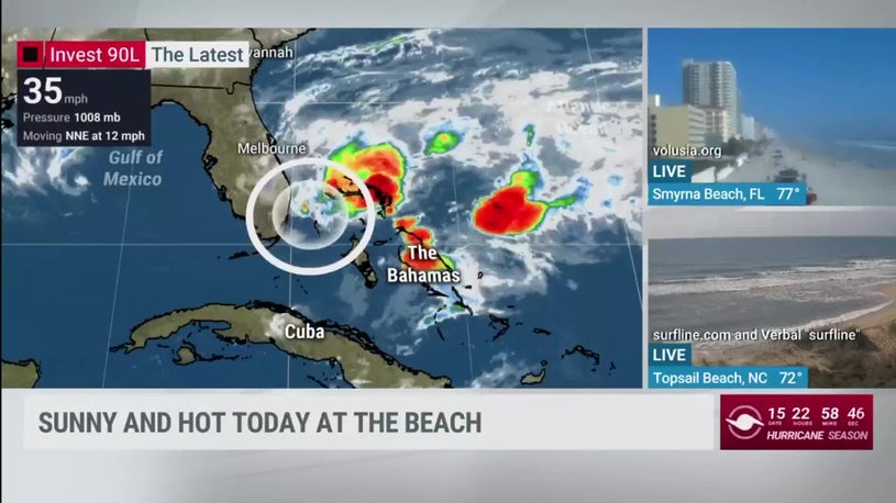
An area of low pressure located near the southeast coast of Florida has been producing disorganized showers and thunderstorms, along with gusty winds over parts of South Florida and the northwestern Bahamas.
Current Radar, Winds, Watches and Warnings
Friday morning, Miami and Ft. Lauderdale took the brunt of the heaviest rain. Rain fell at the rate of almost 2 inches per hour, triggering a flash flood warning for Miami-Dade County, where street flooding was reported to be widespread, according to the National Weather Service.
Thursday, over 5 inches of rain pounded Florida's Middle Keys, a top 10 wettest day all-time in Marathon, Florida, triggering some street flooding. Wind gusts as high as 45 mph were recorded in the Lower Keys Thursday.
This system has been tagged "Invest 90L" by the National Hurricane Center. This tag allows the National Hurricane Center to run specialized hurricane models, send out the Hurricane Hunters and more.
(MORE: What is an Invest?)
Wind shear, a shredding of clouds by varying winds in different layers of the atmosphere, has continued to decrease and become more favorable for slow development of this disturbance since Thursday.
These winds are expected become far more favorable Saturday.
The Hurricane Hunters will investigate this developing system Saturday morning, to help figure out what is going on in the lowest levels of the atmosphere, and to discern if the system has become a tropical or subtropical depression or storm.
Invest 90L is likely to sharpen and acquire characteristics of a subtropical or tropical storm this weekend as it moves northeastward.
(The potential area(s) of tropical development according to the latest National Hurricane Center outlook are shown by polygons, color-coded by the chance of development over the next five days. An "X" indicates the location of a current disturbance. )
A subtropical depression or storm exhibits features of both tropical and non-tropical systems. This includes no cold or warm fronts, a broad wind field and at least some thunderstorms removed some distance from the center.
The National Hurricane Center issues advisories and forecasts for subtropical depressions and storms. They are assigned a number or name, just like a tropical depression or storm. This year's first named storm in the Atlantic basin would be Arthur.
Florida, Bahamas Rain, Wind, Waves
This system will gradually have less impacts over South Florida even as it develops and strengthens because thunderstorms are expected to be on the eastern side of the system, but some showers and thunderstorms are possible into this weekend.
The heaviest rain from the system is expected to fall over the Bahamas through Saturday.
Saturday's Forecast
The system will continue to provide gusty winds to Florida and the Bahamas this weekend.
Those gusty onshore winds will likely create dangerous rip currents and high surf along much of Florida's eastern coast. The National Weather Service in Miami is warning that there is a high risk of rip currents at South Florida beaches. This rip current threat should spread north along Florida's Atlantic beaches through the weekend as the system gains steam.
Where "It" May Track
Once the storm forms, it is then expected to move north-northeast, with its center remaining off the East Coast, tracking somewhere between Bermuda and the Outer Banks of North Carolina by Monday.
It's too soon to determine the exact track, but the low may track close enough to bring some rain and gusty winds to the Outer Banks, possibly the Virginia Tidewater Monday. After that, the low may turn farther out to sea.
Despite this offshore track, the low is expected to bring at least elevated surf and rip currents to beaches from Florida to Georgia, the Carolinas, Virginia Tidewater, and possibly farther north up the Eastern Seaboard into early next week.
There is at least a low chance that this system will be close enough to the East Coast to provide some rainfall from the Carolinas northward to southeastern New England early next week.
It could also bring some coastal flooding at high tide in some of these areas.
Check back with us at weather.com for forecast updates as these details come into focus.
Preseason Storms Have Been Common Lately
This potential development off the Southeast coast is another example of how storms can sometimes form before the hurricane season officially begins on June 1.
Since 2015, at least one named storm has developed before June 1 each hurricane season, some of which had impacts in the United States and elsewhere in the Atlantic Basin.
Tracks of all Atlantic named storms that have formed before June 1 in each hurricane season from 2015 through 2019. The black segments of tracks denote when each system was either a remnant low-pressure center or an area of low pressure before becoming a depression or storm.
(Data: NOAA)Last May, Subtropical Storm Andrea formed southwest of Bermuda the week before Memorial Day, but only lasted about 24 hours.
In 2018, Tropical Storm Alberto made a Memorial Day landfall along the Florida Panhandle, remained intact and took a strange track into Lower Michigan before losing its tropical characteristics.
Tropical Storm Arlene developed even earlier than Alberto and, in 2017, became only the second April Atlantic tropical storm of record.
Perhaps 2016 was the strangest early start to an Atlantic season in recent memory.
Tropical Storm Bonnie soaked the coast of the Carolinas in late-May 2016. But that was preceded by eastern Atlantic Hurricane Alex, only the second known January Atlantic hurricane. Alex eventually made landfall in the Azores as a tropical storm.
In 2015, Tropical Storm Ana made the second-earliest U.S. landfall of at least a tropical storm on record on Mother's Day weekend along the coast of the Carolinas.
This early start also happened in 2012 (Alberto, then Beryl in May), 2008 (Arthur), 2007 (another Subtropical Storm Andrea) and 2003 (another Ana, this time in April). Beryl nearly became a hurricane before coming ashore near Jacksonville Beach, Florida, on Memorial Day weekend 2012.
Nine of 17 years from 2003 through 2019 had at least one named storm before June 1, and there were a total of 11 out-of-season named storms during that time. The majority of these developed and meandered, or made landfall along the coast from North Carolina to northeastern Florida.
The Weather Company’s primary journalistic mission is to report on breaking weather news, the environment and the importance of science to our lives. This story does not necessarily represent the position of our parent company, IBM.
"first" - Google News
May 16, 2020 at 06:37PM
https://ift.tt/3bEayhd
Tropical Storm Arthur, First of the 2020 Atlantic Hurricane Season, Likely This Weekend off Southeast Coast - The Weather Channel
"first" - Google News
https://ift.tt/2QqCv4E
https://ift.tt/3bWWEYd
Bagikan Berita Ini


0 Response to "Tropical Storm Arthur, First of the 2020 Atlantic Hurricane Season, Likely This Weekend off Southeast Coast - The Weather Channel"
Post a Comment